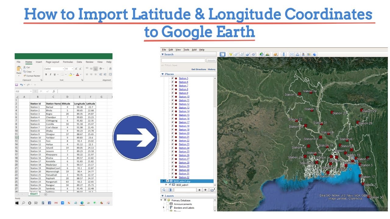
Import Latitude & Longitude Coordinates to Google Earth from CSV Excel file
Hello viewers
Welcome to a new video tutorial in GIS and RS Solution YouTube channel.
In this tutorial, you will learn how to import longitude and latitude coordinate information into Google Earth from a CSV file.
I hope now you will be able to perform How to Import Latitude & Longitude Coordinates to Google Earth. Thank you for watching. See you in the next video.
atoll logiciel


Following your tutorial, I am trying to upload csv file with latitude and longitude into Google Earth Pro. But whenever I upload the csv file Google Earth Pro does not recognize the columns separately, it combines all the columns as one column. At the step select latitude and longitude field, it shows all the tittles as one. I have relooked at the csv file, separated it well with the headings under each column but still. Please can you help me upload this file?
thanks sir. Can we use coordinate in UTM ?
thanks sir!
Thanks sir
Best
So very helpful! Thank you very much.
How do I import altitude from mean sea level?
the last step importing boundary shape file, how is it?
i have difficulties, when you safe the excel file in CSV format and import it on google earth, it not shows the lat/long. I am using macbook. Please advise.
Great video, sir
Shukriya
Thank you brother
Thanks 👍
Thankyou so much
Excellent!
hi
can you please tell how you have downloaded the boundry which you have imported at last
Thanks
how to export Google Earth pro code file
Best video..really helped me!
How to dive the point into folders, is putting everything into one folder 😭
Hello, I am trying to follow along but the import is removing some of the Latitude and Longitude coordinates. I dont understand what is going on.
Sir plz tell help me ….how to calculate distance between two different lat n long in Excel or access plzz plzz
First of all I am thankful for your wonderful efforts. I followed some of your Playlists. You explained very well and made it easy to implement.
Sir I have a request to you, actually I have a problem and don't get any satisfactory solution, please help me in solving it.
Today I have different problem which is not related to this video, please give any solution. My problem is:
I want to divide a polygon in any numbers of sub polygons, area of these sub polygons is varying.
I have total area of polygon and also area of sub polygons and also number of sub polygons.
How can solve this problem?
In any software gqis, arcgis, postgres or any other tool using which you can provide me a solution.
Video is not clear…..!!!!
Salom qalesiz.ArcGisda yangi panel qoshishi o‘rgatin kutyapmiz.🙁
Hello brother , should I need to uninstall the arcgis version in order to install pro version ? please reply ?
Nice vedio. Please sir make a vedio on how to add this file on ArcGIS with shape file and features